
Airstrip Junkies
|
Grand Canyon West – Peach Springs, Arizona
Public / Hualapai Indian Tribe
Elevation 4,800
AZ36 This airport is not really that exciting; it's off the beaten path and that's why I included it. The runway is paved, 5,000-feet in length and sits on a bluff at the west end of the Grand Canyon. The Hualapai Indian Tribe owns it. They also lease it out to a few flight-seeing companies. For $37.00 they take you in a bus to the edge of the canyon and serve lunch. There is a landing fee.
Grand Canyon Bar Ten – 60 S of Whitmore, Arizona
Private / Bar Ten Ranch, Inc.
Elevation 4,100
1Z1 Grand Canyon Bar Ten airstrip is as backcountry as you can get. It is one of only two operating airstrips on the north side of the canyon. Currently the runway extends for 4,600 feet and is considered in "good" condition. It is used by the Bar Ten Ranch to fly in guests and pick them up for flight-seeing adventures around the western canyon area. The airstrip is about 4 miles north of the Colorado River. The only other way to get to the ranch is 80 miles of rugged dirt road from St. George, Utah. A 4x4 vehicle is the only thing that will pass the route.
The north end of the airstrip is 1,500 feet of chip/seal. During the summer season up to 200 people fly in and out of the airstrip on a daily basis, so be sure to look for air traffic. The ranch welcomes private aircraft, but call ahead before arriving. www.bar10.com or 800-582-4139.
Haas International Airstrip – 4 N of Merna, Wyoming
Owner Ben Haas
Elevation 7,980
2WY3 What a story Ben Haas had to tell about his new Haas International Airstrip. We talked on October 14, 2003 about his new toy. Ben built the strip in a former hayfield for emergencies (and his own use). He realized there were no airstrips between Jackson and Pinedale. It is at a high elevation, but the runway extends to nearly 3,000 feet and is located beneath a Federal Airway.
The strip is relatively flat and has wide-open approach from either end. The town of Merna is merely a "crossroad and 17 mailboxes." Ben's ranch consists of 280 acres that surround the airstrip. The runway was recently graded and in perfect shape. The airstrip has the potential for having cattle and antelope on the runway, so a few low-passes may be needed to clear the runway of live obstructions.
CAUTION: Do not confuse the airstrip with a nearby paved, lighted runway that is more than 6,000 feet in length. This strip was built by a doctor and is protected by armed guards with orders to shoot trespassers. This strip is about 4 miles southeast of Ben's airport. The doctor's airport is not listed on any charts.
Permission to use this private airstrip can be had by calling Ben at 307-733-9554.
Heckendorf Ranch / Georgia Pass – Jefferson, Colorado
Private / Bob Heckendorf
Elevation 9,869
77CO Another Colorado gem, Heckendorf Airstrip lies at 9,869 feet, perhaps the second or third highest in the nation. The length is 3,100 feet, but only 1,800 feet is usable with the remainder being used for hay operations. Bob Heckendorf owns the airstrip and is a super nice guy. The strip has a 2:1 slope to the northwest and is one-way in, one-way out. Bob has landed many different types of aircraft on this airstrip including a Twin Otter and Cessna 180. Bob mentions the density altitude can reach 12,000 or 13,000 feet during the summer months. As you can imagine, the airstrip is very demanding.
If you take the time to call Bob and fly with him for the first few times into the strip, he has no problem with you visiting. The strip is about 3.5 miles west of Jefferson, Colorado. The strip is used by Bob and his friends for about 9 months of the year when snow isn't an issue.
Bob Heckendorf 970-524-2500
Jewett Mesa – Apache Creek, New Mexico
Public / Unknown Ownership
Elevation 7,700
 Q13
I have been unable to find or contact the owner for information. The
runway is about 5,200 feet in length and is in very poor condition
with large rocks. The elevation at 7,681 feet produces some high
density altitudes. Each runway approach has obstructions. The strip
is not too airplane/pilot friendly. It is located about 10 miles
north of Apache Creek or about 25 miles south of Quemado, NM.. Large
340 KV high-tension power lines run south of the airstrip. The USFS
confirms runway length as 5,200 x 40 and in fair to poor condition.
There is no windsock. There may be livestock or wildlife on and in
the vicinity of the airstrip.
Q13
I have been unable to find or contact the owner for information. The
runway is about 5,200 feet in length and is in very poor condition
with large rocks. The elevation at 7,681 feet produces some high
density altitudes. Each runway approach has obstructions. The strip
is not too airplane/pilot friendly. It is located about 10 miles
north of Apache Creek or about 25 miles south of Quemado, NM.. Large
340 KV high-tension power lines run south of the airstrip. The USFS
confirms runway length as 5,200 x 40 and in fair to poor condition.
There is no windsock. There may be livestock or wildlife on and in
the vicinity of the airstrip.
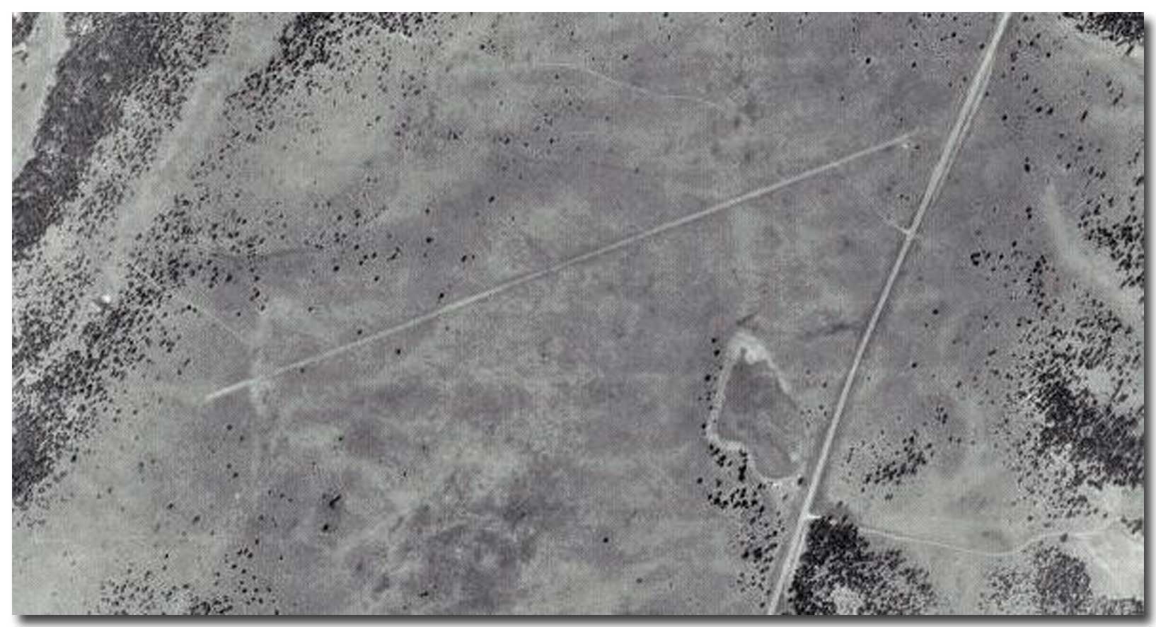
12-08-2008 Talked with a pilot who had flown into Jewett Mesa. He said he had a non-pilot friend walk the strip before he landed there. The approaches are easy; knee-high tall grass covered the runway. There are dangerous-size boulders that make it impossible to pull off the strip. He talked to a Forest Service guy who had been there for 20 years and was told that his was the first airplane he had ever seen at the strip.
Satellite image, click to enlarge
Kinky Creek Divide – Dubois, Wyoming
Private / Open to public use
Elevation 8,803
 WY30
The Kinky Creek Airstrip lies about 30 miles east of the Grand
Tetons, high in the Gros Ventre Mountain Range of northwestern
Wyoming. This is perhaps Wyoming's best backcountry airstrip and it
is open for public use as long as you know "your stuff."
WY30
The Kinky Creek Airstrip lies about 30 miles east of the Grand
Tetons, high in the Gros Ventre Mountain Range of northwestern
Wyoming. This is perhaps Wyoming's best backcountry airstrip and it
is open for public use as long as you know "your stuff."
The airport manager, Sparky Imeson, has provided some great information and images. The airstrip is generally considered one-way in (to the east) and one-way out. It sits in a sage brush and grass covered valley at an elevation of 8,803 feet, Wyoming's highest airport. Luckily for the pilot's sake the runway is long, but narrow with the usable portion about 15-feet wide. The west end (bottom) is rough. A pilot flying in should touchdown about halfway up the runway, landing to the eat) to avoid an even rougher runway surface.
 The
airstrip was made in the 1960s for a nearby guest ranch (Darwin
Ranch). It can not be reached by the Gros Ventre (pronounced "gro
vont") road from Kelly, Wyo. but can be accessed by vehicle in a
round-about manner. Call Sparky for more information on this one.
The
airstrip was made in the 1960s for a nearby guest ranch (Darwin
Ranch). It can not be reached by the Gros Ventre (pronounced "gro
vont") road from Kelly, Wyo. but can be accessed by vehicle in a
round-about manner. Call Sparky for more information on this one.
Note the cattle by the propeller
Lost River Airstrip – Mazama, Washington
Elevation 2,400
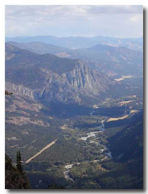 The
Lost River names conjures images of a forgotten creek that flows
through a land unchanged by time. And that isn't all that far from
the truth. The name is fitting for this airstrip that lies along the
river forming it's namesake in north central Washington state. The
strip is adjacent to a small residential resort where you can
purchase or rent cabins and houses in the wilderness.
The
Lost River names conjures images of a forgotten creek that flows
through a land unchanged by time. And that isn't all that far from
the truth. The name is fitting for this airstrip that lies along the
river forming it's namesake in north central Washington state. The
strip is adjacent to a small residential resort where you can
purchase or rent cabins and houses in the wilderness.
Rudy Peterson is the airport manager. We visited in December 2003. He is a nice gentleman and has been flying for 60 years; he served in the Navy during Word War II. (Thank you Rudy)
Lost River strip is best considered one-way in, one-way out although it can be approached safely from either end depending on wind conditions. Land going west and take off to the east (1-percent grade uphill to the west). Airport elevation is 2,400 feet and the runway length is a little over 3,100 feet. Most of the runway is wide, but some parts are as narrow as 90 feet (not really narrow).
View looking east. Note the large mountain rock face to the north of the field and river to the south side.
The airport was built in the 1960s for the resort guest and is still
open to the public except when it is snow covered ... about half of
the year.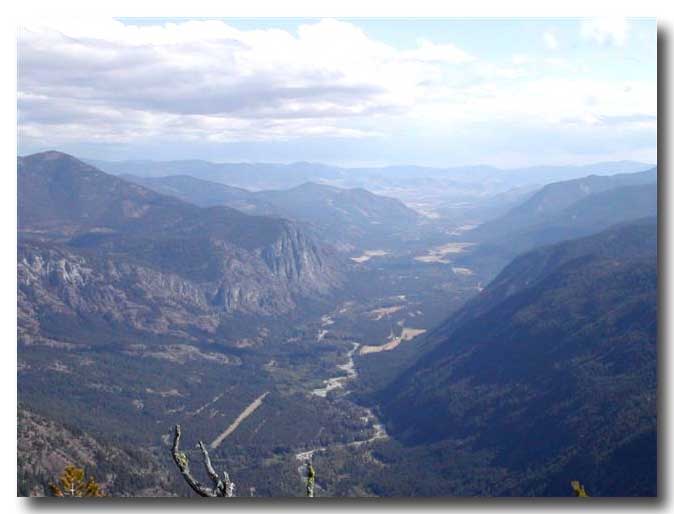
Winds are often from the west in this location. The airport does not see much traffic. Rudy says that rotors can develop over the trees on the approach end of the runway. He also advised there are steep mountains on each of its flanks.
 Looking
east down the valley. The strip is in the lower left corner.
Looking
east down the valley. The strip is in the lower left corner.
Looking to the east at the airstrip from a nearby mountain.
Call Rudy to ask for further information 509-996-2385.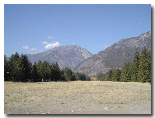
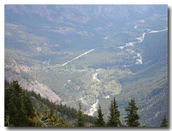
Runway 29 looking west. The mountain get rugged.
 Runway
11 looking east when the mountains transition to plains.
Runway
11 looking east when the mountains transition to plains.
Luckinbill Airstrip – 37 W of Cody, Wyoming
Private / Larry Luckinbill
Elevation 6,600
WY06 Luckinbill Airstrip lies at the southern foot of Beartooth Pass that is one of Montana's most scenic byways. Having been over this pass in late May 2002, I can vouch for the scenery from the 11,010-foot pass.
The lone runway, 8/26, is approximately 2,400-feet of dirt and
gravel at an elevation of 6,600 feet. The airstrip is private and
very dangerous according to its owner. No other information is
available. Manzanita Airstrip –
Mariposa, California Elevation 3,020 Although this airstrip sits only 3 miles from a main
road it can be considered backcountry because of the layout. The
strip is at an elevation of 3,020 feet with the total runway length
of 1,100 feet. It is smooth and well maintained turf. It slopes
uphill to the north about 4 degrees. Arrivals are made to the north
and departure to the south. The airstrip lies east (090º) from the
Mariposa-Yosemite Airport. Joe says the airstrip is seldom used because he sold
his airplane not long ago, although he intends on buying another
soon. The strip has a slight dogleg at the top of the hill. It is
necessary to be careful not to hit the hangar. The name, Manzanita,
comes from a mountain tree. Joes has no problem with people landing
on the airstrip if you call ahead. Joseph 209-742-7924. Me-Own USFS Airstrip – N of Silver City, New
Mexico Elevation 7,450 1NM0 Me-Own airstrip is located
about 34 miles north of the hamlet of Silver City, New Mexico. It
sits in the 3-million acre Hila National Forest. The airstrip is
used for forest fire suppression during the summer fire season from
late April to July. Outside the fire season the airstrip is seldom
used. The USFS commented that the strip is not used as a "fire
suppression base." The single dirt runway, 14/32, runs 3,875 feet in
length and 70 feet in width. The surrounding terrain is heavily
timbered by pinion and juniper trees. The strip is located on top of
a mesa where both approach ends drop off into a steep canyon. The
airstrip is not regularly maintained, but seems to keep itself in
good shape overall. Livestock and wildlife may be on the runway or
in the immediate vicinity. Downdrafts and turbulence will be found when
arriving and departing during the afternoon hours. A drainage ditch
runs along both side of the strip. There is a windsock and plenty of aircraft parking.
Although listed as "private" on section charts the airstrip is open
to the public, just be cautious of the fire-fighting airplanes and
helicopters that may be in the area. Announce your intentions of
120.750. For more information, Charlie 505-536-2250, or Everett Weniger 505-388-8451 I have been listed
as the contact for backcountry airstrips on the Gila National Forest
in New Mexico for the last two years of so. That has been fine. I
have received a few calls from pilot needing information. Now I am
retiring and will not be here. Who knows who will answer the phone.
My position will not be filed for some months. I would suggest
calling Gila National Forest Dispatch Center to get the name of the
new contact. They will not know who it is until around May 2006. Ask
them who has the Aviation Program Manager duties. Phone 505-388-8368
and ask for Big Willy. Melby Ranch – San Luis, Colorado Elevation 8,800 33CO Melby Ranch is just that, a
ranch. In this case it's a ranch of home, or in east-coast terms, a
subdivision. The strip is long at 7,400 feet and is one of America's
highest airstrips at 8,800-foot elevation. The runway itself is
40-feet wide and rolls along a flat, sage-covered plain. It is south
of the San Luis Reservoir. Want to buy a house with a view? Check
them out at www.melbyranch.com Mesawood Airpark – Cedaredge, Colorado Elevation 7,200
Runway 16/34 is considerably uphill to the north and
there is 181-feet elevation different between runway ends. If it
rains hard during the summer the runway can get bumpy from the
drainage. The runway elevation is 7,200 feet with the runway 2,400
feet by 60 feet. Check density altitude. Locating the strip is easy
as the only one in the general area with a gravel road cutting
across the middle leading down to a hayfield. There are many trees and hills in the area that
require moving around them to make the approach. Mr. Thrumpfheller
has no problem with visitor as long as you ask first by calling him
at 970-856-6785. He is a very nice gentleman.
Private / Joseph Carbaugh
Private / Evan L Melby
Robert Thrumpfheller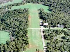 6CO2
Located north-northeast of Delta, Colo. Mesawood Airpark currently
sits under about two feet of snow (03-18-2005). During the flying
season the airport is open and well maintained by its owner.
6CO2
Located north-northeast of Delta, Colo. Mesawood Airpark currently
sits under about two feet of snow (03-18-2005). During the flying
season the airport is open and well maintained by its owner.
![]()
![]()